
Mapa topográfico Austin
Mapa interativo
Clique no mapa para exibir a altitude.
Sobre este mapa
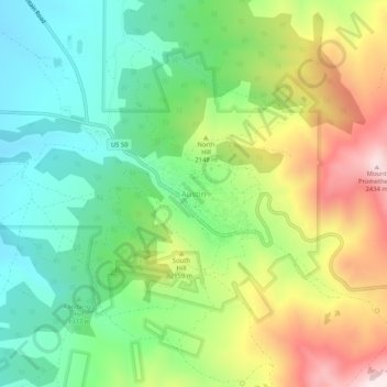
Nome: Mapa topográfico Austin, altitude, relevo.
Local: Austin, Lander County, Nevada, United States (39.47326 -117.08954 39.51326 -117.04954)
Altitude média: 2076 m
Altitude mínima: 1841 m
Altitude máxima: 2464 m
Austin is an unincorporated small town in, and former county seat of, Lander County, Nevada, United States. In 2020, the census-designated place of Austin had a population of 167. It is located on the western slopes of the Toiyabe Range at an elevation of 6,575 feet (2,004 m). U.S. Route 50 passes through the town.
Outros mapas topográficos
Clique em um mapa para visualizar sua topografia, sua altitude e seu relevo.
Kingston
United States > Nevada > Lander County
Kingston, Lander County, Nevada, United States
Altitude média: 1964 m
Battle Mountain
United States > Nevada > Lander County
Battle Mountain, Lander County, Nevada, United States
Altitude média: 1376 m