
Mapa topográfico Louisville
Mapa interativo
Clique no mapa para exibir a altitude.
Sobre este mapa
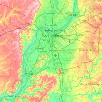
Nome: Mapa topográfico Louisville, altitude, relevo.
Local: Louisville, Jefferson County, Kentucky, United States (37.99710 -85.94706 38.38014 -85.40510)
Altitude média: 188 m
Altitude mínima: 114 m
Altitude máxima: 306 m
Throughout January 1937, 19.17 inches (48.7 cm) of rain fell in Louisville, and by January 27, the Ohio River crested at a record 57.15 feet (17.42 m), almost 30 feet (9.1 m) above flood stage. These events triggered the "Great Flood of 1937", which lasted into early February. The flood submerged 60–70 percent of the city, caused complete loss of power for four days, and forced the evacuation of 175,000 or 230,000 residents, depending on sources. Ninety people died as a result of the flood. It led to dramatic changes in where residents lived. Today, the city is protected by numerous flood walls. After the flood, the areas of high elevation in the eastern part of the city had decades of residential growth.
Outros mapas topográficos
Clique em um mapa para visualizar sua topografia, sua altitude e seu relevo.
Shawneeland
United States > Kentucky > Jefferson County > Louisville
Shawneeland, Louisville, Jefferson County, Kentucky, 40211, United States
Altitude média: 138 m
Shively
United States > Kentucky > Jefferson County
Shively, Jefferson County, Kentucky, United States
Altitude média: 141 m
Waverly Hills
United States > Kentucky > Jefferson County > Louisville
Waverly Hills, Louisville, Jefferson County, Kentucky, 40258, United States
Altitude média: 155 m
Worthington Hills
United States > Kentucky > Jefferson County
Worthington Hills, Jefferson County, Kentucky, United States
Altitude média: 221 m
Cherokee Park
United States > Kentucky > Jefferson County > Louisville
Cherokee Park, Louisville, Jefferson County, Kentucky, United States
Altitude média: 159 m
Spring Mill
United States > Kentucky > Jefferson County
Spring Mill, Jefferson County, Kentucky, United States
Altitude média: 195 m
Strathmoor Manor
United States > Kentucky > Jefferson County
Strathmoor Manor, Jefferson County, Kentucky, United States
Altitude média: 161 m
Parkland
United States > Kentucky > Jefferson County > Louisville
Parkland, Louisville, Jefferson County, Kentucky, 40211, United States
Altitude média: 139 m
Saint Matthews
United States > Kentucky > Jefferson County > Louisville
Saint Matthews, Louisville, Jefferson County, Kentucky, 40207, United States
Altitude média: 166 m
Cherokee Garden
United States > Kentucky > Jefferson County > Louisville
Cherokee Garden, Louisville, Jefferson County, Kentucky, 40041, United States
Altitude média: 164 m
Briarwood
United States > Kentucky > Jefferson County
Briarwood, Jefferson County, Kentucky, 40242, United States
Altitude média: 189 m
Newburg
United States > Kentucky > Jefferson County > Louisville
Newburg, Louisville, Jefferson County, Kentucky, 40225, United States
Altitude média: 156 m
West Buechel
United States > Kentucky > Jefferson County
West Buechel, Jefferson County, Kentucky, United States
Altitude média: 150 m
Louisville-Jefferson County (Balance)
United States > Kentucky > Jefferson County > Louisville
Louisville-Jefferson County (Balance), Louisville, Jefferson County, Kentucky, 40231, United States
Altitude média: 157 m
Lyndon
United States > Kentucky > Jefferson County
Lyndon, Jefferson County, Kentucky, 40222, United States
Altitude média: 182 m
Druid Hills
United States > Kentucky > Jefferson County
Druid Hills, Jefferson County, Kentucky, United States
Altitude média: 169 m
South Park
United States > Kentucky > Jefferson County > Louisville
South Park, Louisville, Jefferson County, Kentucky, 40118, United States
Altitude média: 149 m
Audubon Park
United States > Kentucky > Jefferson County > Audubon Park
Audubon Park, Jefferson County, Kentucky, United States
Altitude média: 155 m
Mirror Lakes
United States > Kentucky > Jefferson County > Louisville > Hopewell
Mirror Lakes, Hopewell, Louisville, Jefferson County, Kentucky, United States
Altitude média: 198 m
Anchorage
United States > Kentucky > Jefferson County > Anchorage
Anchorage, Jefferson County, Kentucky, United States
Altitude média: 219 m
Falls of the Ohio State Park
United States > Kentucky > Jefferson County > Louisville
Falls of the Ohio State Park, Louisville, Jefferson County, Kentucky, United States
Altitude média: 135 m
Bellewood
United States > Kentucky > Jefferson County > St. Matthews > Bellewood
Bellewood, St. Matthews, Jefferson County, Kentucky, 40041, United States
Altitude média: 167 m
Meadow Vale
United States > Kentucky > Jefferson County > Meadow Vale
Meadow Vale, Jefferson County, Kentucky, United States
Altitude média: 201 m
Fern Creek
United States > Kentucky > Jefferson County > Louisville
Fern Creek, Louisville, Jefferson County, Kentucky, 40291, United States
Altitude média: 211 m
Jeffersontown
United States > Kentucky > Jefferson County
Jeffersontown, Jefferson County, Kentucky, 40299, United States
Altitude média: 207 m
Indian Hills
United States > Kentucky > Jefferson County
Indian Hills, Jefferson County, Kentucky, United States
Altitude média: 161 m
Prospect
United States > Kentucky > Jefferson County
Prospect, Jefferson County, Kentucky, United States
Altitude média: 166 m
Glenview
United States > Kentucky > Jefferson County
Glenview, Jefferson County, Kentucky, 40025, United States
Altitude média: 155 m
Fincastle
United States > Kentucky > Jefferson County
Fincastle, Jefferson County, Kentucky, United States
Altitude média: 218 m
St. Matthews
United States > Kentucky > Jefferson County
St. Matthews, Jefferson County, Kentucky, 40207, United States
Altitude média: 167 m
Bethany
United States > Kentucky > Jefferson County > Louisville
Bethany, Louisville, Jefferson County, Kentucky, 40272, United States
Altitude média: 141 m
Forest Hills
United States > Kentucky > Jefferson County
Forest Hills, Jefferson County, Kentucky, United States
Altitude média: 202 m
Coldstream
United States > Kentucky > Jefferson County
Coldstream, Jefferson County, Kentucky, United States
Altitude média: 219 m
Fairdale
United States > Kentucky > Jefferson County > Louisville
Fairdale, Louisville, Jefferson County, Kentucky, 40118, United States
Altitude média: 158 m