
Mapa topográfico Apple Valley
Mapa interativo
Clique no mapa para exibir a altitude.
Sobre este mapa
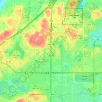
Nome: Mapa topográfico Apple Valley, altitude, relevo.
Local: Apple Valley, Dakota County, Minnesota, 55124, United States (44.71734 -93.24835 44.77589 -93.15134)
Altitude média: 301 m
Altitude mínima: 270 m
Altitude máxima: 343 m
According to the United States Census Bureau, the city has a total area of 17.57 square miles (45.51 km2), of which 16.86 square miles (43.67 km2) is land and 0.71 square miles (1.84 km2) is water. The city's geography is rolling, with elevation from the lowest to the highest points in the city varying by one hundred feet (thirty metres) or more. The downtown area and its adjacent residential district (which formed the original core of the city when it was incorporated) are in a shallow valley.
Outros mapas topográficos
Clique em um mapa para visualizar sua topografia, sua altitude e seu relevo.
Eagan
United States > Minnesota > Dakota County
Eagan, Dakota County, Minnesota, United States
Altitude média: 267 m
West St. Paul
United States > Minnesota > Dakota County
West St. Paul, Dakota County, Minnesota, 55118, United States
Altitude média: 294 m
Vermillion
United States > Minnesota > Dakota County
Vermillion, Dakota County, Minnesota, 55085, United States
Altitude média: 260 m
Randolph
United States > Minnesota > Dakota County
Randolph, Dakota County, Minnesota, United States
Altitude média: 270 m
Miesville
United States > Minnesota > Dakota County
Miesville, Dakota County, Minnesota, United States
Altitude média: 289 m
Coates
United States > Minnesota > Dakota County
Coates, Dakota County, Minnesota, United States
Altitude média: 280 m
Sunfish Lake
United States > Minnesota > Dakota County
Sunfish Lake, Dakota County, Minnesota, United States
Altitude média: 287 m
Lilydale
United States > Minnesota > Dakota County
Lilydale, Dakota County, Minnesota, United States
Altitude média: 257 m
Chimney Rock Scenic and Natural Area
United States > Minnesota > Dakota County
Chimney Rock Scenic and Natural Area, Joan Avenue, Marshan Township, Dakota County, Minnesota, United States
Altitude média: 269 m
Waterford Township
United States > Minnesota > Dakota County
Waterford Township, Dakota County, Minnesota, United States
Altitude média: 284 m
Etter
United States > Minnesota > Dakota County
Etter, Ravenna Township, Dakota County, Minnesota, United States
Altitude média: 233 m
New Trier
United States > Minnesota > Dakota County
New Trier, Dakota County, Minnesota, United States
Altitude média: 300 m
Hampton
United States > Minnesota > Dakota County
Hampton, Dakota County, Minnesota, 55031, United States
Altitude média: 297 m
Carlson Lake
United States > Minnesota > Dakota County > Eagan
Carlson Lake, Eagan, Dakota County, Minnesota, United States
Altitude média: 280 m
Burnsville
United States > Minnesota > Dakota County
Burnsville, Dakota County, Minnesota, United States
Altitude média: 271 m
Mendota Heights
United States > Minnesota > Dakota County
Mendota Heights, Dakota County, Minnesota, 55120, United States
Altitude média: 265 m
Empire
United States > Minnesota > Dakota County
Empire, Dakota County, Minnesota, United States
Altitude média: 280 m
Hastings
United States > Minnesota > Dakota County
Hastings, Dakota County, Minnesota, 55033, United States
Altitude média: 241 m
Lakeville
United States > Minnesota > Dakota County
Lakeville, Dakota County, Minnesota, 55044, United States
Altitude média: 305 m
Inver Grove Heights
United States > Minnesota > Dakota County
Inver Grove Heights, Dakota County, Minnesota, United States
Altitude média: 260 m
Farmington
United States > Minnesota > Dakota County > Farmington > Farmington
Farmington, Dakota County, Minnesota, 55024, United States
Altitude média: 280 m
Waterford
United States > Minnesota > Dakota County > Waterford
Waterford, Dakota County, Minnesota, 55057, United States
Altitude média: 289 m
Mendota
United States > Minnesota > Dakota County
Mendota, Dakota County, Minnesota, 55150, United States
Altitude média: 242 m
Pig's Eye Island Heron Rookery SNA
United States > Minnesota > Dakota County > South St. Paul
Pig's Eye Island Heron Rookery SNA, Hardman Avenue North, South St. Paul, Dakota County, Minnesota, 55075, United States
Altitude média: 221 m
Burnsville
United States > Minnesota > Dakota County > Burnsville > Burnsville
Burnsville, Dakota County, Minnesota, 55337, United States
Altitude média: 275 m
Lakeville
United States > Minnesota > Dakota County > Lakeville > Lakeville
Lakeville, Dakota County, Minnesota, 55044, United States
Altitude média: 306 m
Rosemount
United States > Minnesota > Dakota County
Rosemount, Dakota County, Minnesota, 55068, United States
Altitude média: 287 m
Farmington
United States > Minnesota > Dakota County
Farmington, Dakota County, Minnesota, 55024, United States
Altitude média: 280 m
South Saint Paul
United States > Minnesota > Dakota County
South Saint Paul, Dakota County, Minnesota, 55075, United States
Altitude média: 257 m