
Mapa topográfico Vlotho
Mapa interativo
Clique no mapa para exibir a altitude.
Sobre este mapa
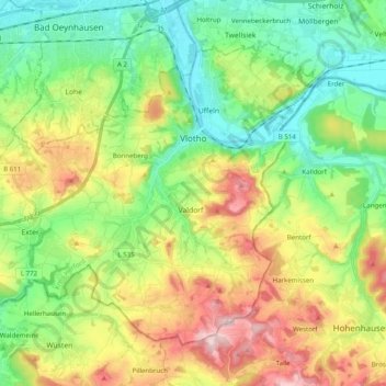
Nome: Mapa topográfico Vlotho, altitude, relevo.
Local: Vlotho, Kreis Herford, Noordrijn-Westfalen, 32602, Duitsland (52.10149 8.72916 52.19690 8.92672)
Altitude média: 149 m
Altitude mínima: 42 m
Altitude máxima: 333 m
Outros mapas topográficos
Clique em um mapa para visualizar sua topografia, sua altitude e seu relevo.
Hiddenhausen
Duitsland > Noordrijn-Westfalen > Kreis Herford
Hiddenhausen, Kreis Herford, Noordrijn-Westfalen, 32120, Duitsland
Altitude média: 92 m
Kirchlengern
Duitsland > Noordrijn-Westfalen > Kreis Herford
Kirchlengern, Kreis Herford, Noordrijn-Westfalen, Duitsland
Altitude média: 80 m
Bonneberg
Duitsland > Noordrijn-Westfalen > Kreis Herford > Vlotho > Bonneberg
Bonneberg, Vlotho, Kreis Herford, Noordrijn-Westfalen, 32602, Duitsland
Altitude média: 150 m
Löhne
Duitsland > Noordrijn-Westfalen > Kreis Herford
Löhne, Kreis Herford, Noordrijn-Westfalen, 32584, Duitsland
Altitude média: 93 m
Vlotho
Duitsland > Noordrijn-Westfalen > Kreis Herford > Vlotho
Vlotho, Kreis Herford, Noordrijn-Westfalen, 32602, Duitsland
Altitude média: 119 m
Herford-Stadt
Duitsland > Noordrijn-Westfalen > Kreis Herford
Herford-Stadt, Herford, Kreis Herford, Noordrijn-Westfalen, Duitsland
Altitude média: 91 m