
Mapa topográfico Qom
Mapa interativo
Clique no mapa para exibir a altitude.
Sobre este mapa
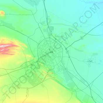
Nome: Mapa topográfico Qom, altitude, relevo.
Local: Qom, بخش مرکزی, Qom County, Qom Province, 37156-57849, Iran (34.48231 50.72010 34.80231 51.04010)
Altitude média: 959 m
Altitude mínima: 833 m
Altitude máxima: 1591 m
The city's topography in the 10th century still reflected the evolutionary merging of the original six villages; these were still separated by fields. The town center was located in the village of Mamajjān, which was connected to other parts of the city on the other side of the river by four bridges. There were about eight squares whose function is not clear and three mosques within the city. There is almost no information about madrasas. The sanctuary must have still been quite small as only two cupolas are mentioned. A bazaar and bathhouses must have existed, too, as well as certain administrative buildings (prison, mint). Five bigger and eight smaller roads indicate good traffic connections, which were supported by at least three or maybe even nine city gates.
Outros mapas topográficos
Clique em um mapa para visualizar sua topografia, sua altitude e seu relevo.
Pardisan
Iran > Qom Province > Qom
Pardisan, Qom, بخش مرکزی, Qom County, Qom Province, 3749113357, Iran
Altitude média: 1024 m