
Mapa topográfico Windermere Island
Mapa interativo
Clique no mapa para exibir a altitude.
Sobre este mapa
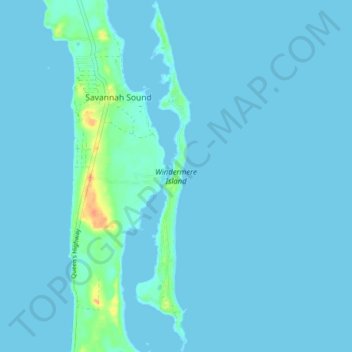
Nome: Mapa topográfico Windermere Island, altitude, relevo.
Local: Windermere Island, Central Eleuthera, The Bahamas (25.03481 -76.12671 25.10605 -76.11428)
Altitude média: 3 m
Altitude mínima: 0 m
Altitude máxima: 39 m
Outros mapas topográficos
Clique em um mapa para visualizar sua topografia, sua altitude e seu relevo.
North Palmetto Point
The Bahamas > Central Eleuthera
North Palmetto Point, Central Eleuthera, The Bahamas
Altitude média: 9 m
Savannah Sound
The Bahamas > Central Eleuthera
Savannah Sound, Central Eleuthera, The Bahamas
Altitude média: 5 m