Geolocalizar

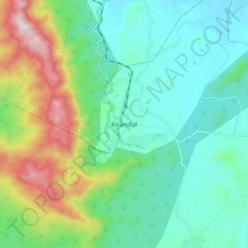
Mapa topográfico Kirandul

Clique no mapa para exibir a altitude.

Kirandul

The Kothavalasa–Kirandul line of East Coast Railway from Kirandul to Visakhapatnam via Koraput is laid through the Eastern Ghats. Up to Araku station, it has many tunnels. Also it pass through the highest elevation Broad gauge station in the Eastern ghats, Semiliguda, just before the Borra caves. Kirandul - Kottavalasa Railroad is the record high Broad Gauge line in the Eastern Ghats. The KK Line has the distinction of being the second highest broad gauge railway line in the country after the one in Jammu.

Wikipedia (CC-BY-SA 3.0)

Sobre este mapa

Nome: Mapa topográfico Kirandul, altitude, relevo.

Local: Kirandul, Kuakonda Tahsil, Dantewada, Chhattisgarh, 494556, India (18.59332 81.21916 18.67332 81.29916)

Altitude média: 742 m

Altitude mínima: 541 m

Altitude máxima: 1270 m

Prepare-se para a sua próxima aventura:

🧗Corda Paracord 550 - Corda multifunções extremamente resistente para sobrevivência
🩹Kits de Primeiros Socorros Portáteis - Essenciais de emergência compactos para entusiastas de outdoor
🔋Power Banks Solares Impermeáveis - Carregadores robustos para manter dispositivos ativos em expedições longas
🧤Luvas Térmicas Táteis - Luvas quentes que permitem utilizar ecrãs de GPS e smartphones
🧤Luvas Outdoor - Proteção térmica para atividades ao ar livre

Como Associado da Amazon, este site recebe uma comissão sobre compras elegíveis sem custo adicional para si.