
Mapa topográfico Tagaytay
Mapa interativo
Clique no mapa para exibir a altitude.
Sobre este mapa
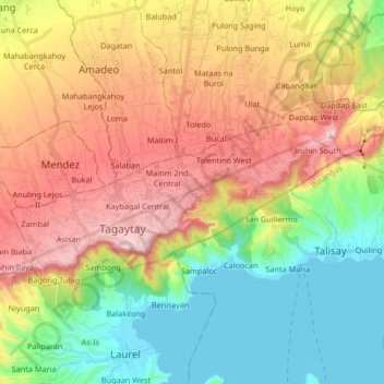
Nome: Mapa topográfico Tagaytay, altitude, relevo.
Local: Tagaytay, Cavite, Calabarzon, 4120, Philippines (14.07911 120.88591 14.15765 121.05140)
Altitude média: 314 m
Altitude mínima: 3 m
Altitude máxima: 728 m
The southern and eastern portions of Tagaytay are covered by hills and mountains which is generally forests, pine trees and open grasslands. The city lies along Tagaytay Ridge, a ridge stretching about 32 kilometres (20 mi) from Mount Batulao in the west to Mount Sungay in the east with elevations averaging about 610 metres (2,000 ft) above sea level. Mount Sungay, in Tagaytay, is the highest point of the province of Cavite at 709 metres (2,326 ft).
Outros mapas topográficos
Clique em um mapa para visualizar sua topografia, sua altitude e seu relevo.
Asisan
Philippines > Cavite > Tagaytay
Asisan, Tagaytay, Cavite, Calabarzon, 4120, Philippines
Altitude média: 526 m
Tagaytay
Philippines > Cavite > Tagaytay
Tagaytay, Cavite, Calabarzon, 4120, Philippines
Altitude média: 225 m