
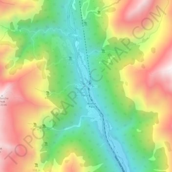
Mapa topográfico Arthur's Pass
Mapa interativo
Clique no mapa para exibir a altitude.
Sobre este mapa
Nome: Mapa topográfico Arthur's Pass, altitude, relevo.
Altitude média: 1204 m
Altitude mínima: 706 m
Altitude máxima: 1834 m
Arthur's Pass township is about five kilometres (3.1 mi) south of the mountain pass with the same name. At an elevation of 740 metres (2,430 ft) above sea level, the settlement is surrounded by beech forest. The Bealey River runs through the township. The town is located 153 kilometres (95 mi) from Christchurch, a two-hour drive on State Highway 73.
Outros mapas topográficos
Clique em um mapa para visualizar sua topografia, sua altitude e seu relevo.
Puketeraki
New Zealand > Canterbury > Selwyn District
Puketeraki, Selwyn District, Canterbury, New Zealand
Altitude média: 1369 m
Hydra Island
New Zealand > Canterbury > Selwyn District
Hydra Island, Selwyn District, Canterbury, New Zealand
Altitude média: 474 m
Selwyn
New Zealand > Canterbury > Selwyn District
Selwyn, Selwyn District, Canterbury, 7682, New Zealand
Altitude média: 70 m
Greendale
New Zealand > Canterbury > Selwyn District
Greendale, Selwyn District, Canterbury, 7671, New Zealand
Altitude média: 132 m
Rolleston
New Zealand > Canterbury > Selwyn District
Rolleston, Selwyn District, Canterbury, 7643, New Zealand
Altitude média: 54 m
Lincoln
New Zealand > Canterbury > Selwyn District
Lincoln, Selwyn District, Canterbury, 7608, New Zealand
Altitude média: 15 m
Darfield
New Zealand > Canterbury > Selwyn District
Darfield, Selwyn District, Canterbury, 7510, New Zealand
Altitude média: 202 m
Mount Cotton
New Zealand > Canterbury > Selwyn District
Mount Cotton, Selwyn District, Canterbury, New Zealand
Altitude média: 1031 m