

Mapa topográfico Wells
Clique no mapa para exibir a altitude.
Wells
Wells doesn't have a weather station, but Barkerville does (located 7 km (4.3 mi) away). Wells has a subarctic climate (Köppen climate classification Dfc), resulting in long, cold and snowy winters, accompanied by short and cool summers due to its high altitude and latitude. Its growing season averages only 66 days. It is located at the mouth of Jack of Clubs Creek, and defined as the source of the Willow River at the outflow of the Jack of Clubs Lake.
Sobre este mapa
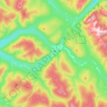
Nome: Mapa topográfico Wells, altitude, relevo.
Altitude média: 1439 m
Altitude mínima: 1112 m
Altitude máxima: 1982 m
Outros mapas topográficos
Clique em um mapa para visualizar sua topografia, sua altitude e seu relevo.

Nemaiah Valley
Canada > British Columbia > Cariboo Regional District > Area J (West Chilcotin)
Altitude média: 1270 m
Strathnaver
Canada > British Columbia > Cariboo Regional District > Area B (Quesnel West/Bouchie Lake)
Altitude média: 715 m
Dunkley
Canada > British Columbia > Cariboo Regional District > Area B (Quesnel West/Bouchie Lake)
Altitude média: 724 m

Asperity Mountain
Canada > British Columbia > Cariboo Regional District > Area J (West Chilcotin)
Altitude média: 2990 m