
Mapa topográfico Blonay
Mapa interativo
Clique no mapa para exibir a altitude.
Sobre este mapa
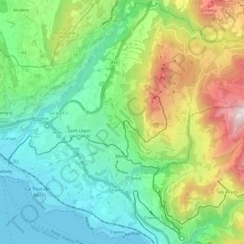
Nome: Mapa topográfico Blonay, altitude, relevo.
Altitude média: 885 m
Altitude mínima: 367 m
Altitude máxima: 1733 m
Blonay overlooks Lake Geneva, with the hill 'Les Pléiades' behind the town. The municipality stretches from an elevation of about 500 to 1,400 m (1,600 to 4,600 ft). It consists of the village of Blonay with the sections of Tercier and Cojonnex and a number of hamlets including Les Chevalleyres.
Outros mapas topográficos
Clique em um mapa para visualizar sua topografia, sua altitude e seu relevo.
Veveyse
Switzerland > Vaud > District de la Riviera-Pays-d’Enhaut > Blonay - Saint-Légier
Veveyse, Blonay - Saint-Légier, District de la Riviera-Pays-d’Enhaut, Vaud, 1809, Switzerland
Altitude média: 742 m