
Mapa topográfico Cedar City
Mapa interativo
Clique no mapa para exibir a altitude.
Sobre este mapa
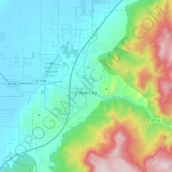
Nome: Mapa topográfico Cedar City, altitude, relevo.
Local: Cedar City, Iron County, Utah, United States (37.61847 -113.19797 37.74748 -113.01272)
Altitude média: 1975 m
Altitude mínima: 1676 m
Altitude máxima: 2866 m
Cedar City is located in the southeast Great Basin and is approximately 20 miles (32 km) north of the northeastern edge of the Mojave Desert. Its elevation of 5,846 feet (1,782 m) gives it a somewhat cooler climate compared to the nearby St. George region, though it retains cultural ties to the city —for example, they share a daily newspaper.
Outros mapas topográficos
Clique em um mapa para visualizar sua topografia, sua altitude e seu relevo.
Parowan
United States > Utah > Iron County
Parowan, Iron County, Utah, 84761, United States
Altitude média: 2002 m
Cedar Breaks
United States > Utah > Iron County
Cedar Breaks, Iron County, Utah, United States
Altitude média: 2843 m
Brian Head
United States > Utah > Iron County > Brian Head
Brian Head, Iron County, Utah, 84719, United States
Altitude média: 3031 m