
Mapa topográfico Brunssummerheide
Mapa interativo
Clique no mapa para exibir a altitude.
Sobre este mapa
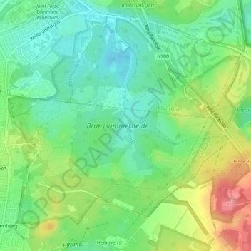
Nome: Mapa topográfico Brunssummerheide, altitude, relevo.
Altitude média: 104 m
Altitude mínima: 70 m
Altitude máxima: 164 m
Outros mapas topográficos
Clique em um mapa para visualizar sua topografia, sua altitude e seu relevo.
Wilhelminaberg
Nederland > Limburg > Landgraaf
Wilhelminaberg, Landgraaf, Limburg, Nederland, 6372VG, Nederland
Altitude média: 147 m
Kasteel Strijthagen
Nederland > Limburg > Landgraaf
Kasteel Strijthagen, Rouenhof, Eikske, Landgraaf, Limburg, Nederland, 6372PW, Nederland
Altitude média: 137 m