
Mapa topográfico Spiekeroog
Mapa interativo
Clique no mapa para exibir a altitude.
Sobre este mapa
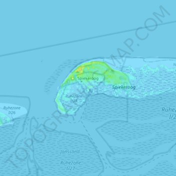
Nome: Mapa topográfico Spiekeroog, altitude, relevo.
Local: Spiekeroog, Landkreis Wittmund, Lower Saxony, 26474, Germany (53.74969 7.66598 53.78232 7.81724)
Altitude média: 0 m
Altitude mínima: -2 m
Altitude máxima: 16 m
Outros mapas topográficos
Clique em um mapa para visualizar sua topografia, sua altitude e seu relevo.
Wold
Germany > Lower Saxony > Landkreis Wittmund > Holtgast
Wold, Holtgast, Samtgemeinde Esens, Landkreis Wittmund, Lower Saxony, 26427, Germany
Altitude média: 2 m
Friedeburg
Germany > Lower Saxony > Landkreis Wittmund
Friedeburg, Landkreis Wittmund, Lower Saxony, 26446, Germany
Altitude média: 7 m
Esens
Germany > Lower Saxony > Landkreis Wittmund
Esens, Samtgemeinde Esens, Landkreis Wittmund, Lower Saxony, Germany
Altitude média: 1 m
Werdum
Germany > Lower Saxony > Landkreis Wittmund
Werdum, Samtgemeinde Esens, Landkreis Wittmund, Lower Saxony, Germany
Altitude média: -1 m
Spiekeroog
Germany > Lower Saxony > Landkreis Wittmund > Spiekeroog
Spiekeroog, Landkreis Wittmund, Lower Saxony, 26474, Germany
Altitude média: 0 m