
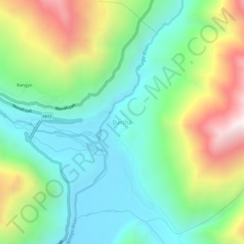
Mapa topográfico Darcha
Mapa interativo
Clique no mapa para exibir a altitude.
Sobre este mapa
Nome: Mapa topográfico Darcha, altitude, relevo.
Altitude média: 3702 m
Altitude mínima: 3284 m
Altitude máxima: 4563 m
Darcha also known as Dartse (elevation 3,360 m or 11,020 ft) is a pair of villages (Darcha Sumdo and Darach Dangma) on the Bhaga River in the Lahaul sub-division in the Lahaul and Spiti district in the Indian state of Himachal Pradesh. It is the northernmost permanent settlement in Himachal Pradesh along the Manali-Leh Highway. With the opening of the Atal Tunnel, Darcha is likely to see a large influx of tourists as it is now connected to Manali throughout the year. The Nimmu–Padam–Darcha road which is being constructed, will improve connectivity of Kargil, Zanskar and Leh District of Ladakh to Darcha.
Outros mapas topográficos
Clique em um mapa para visualizar sua topografia, sua altitude e seu relevo.
Chandratal Lake
India > Himachal Pradesh > Lahul
Chandratal Lake, Lahul, Lahaul and Spiti District, Himachal Pradesh, India
Altitude média: 4403 m
Sarchu
India > Himachal Pradesh > Lahul
Sarchu, Lahul, Lahul and Spiti, Himachal Pradesh, India
Altitude média: 5408 m
Teling
India > Himachal Pradesh > Lahul
Teling, Lahul, Lahul and Spiti, Himachal Pradesh, India
Altitude média: 3527 m
Koksar
India > Himachal Pradesh > Lahul
Koksar, Lahul, Lahul and Spiti, Himachal Pradesh, India
Altitude média: 3634 m
Sissu
India > Himachal Pradesh > Lahul > Sissu
Sissu, Lahul, Lahul and Spiti, Himachal Pradesh, India
Altitude média: 4343 m
Chikka
India > Himachal Pradesh > Lahul
Chikka, Lahul, Lahaul and Spiti District, Himachal Pradesh, India
Altitude média: 4094 m
Rohtang Pass
India > Himachal Pradesh > Lahul
Rohtang Pass, Lahul, Lahul and Spiti, Himachal Pradesh, India
Altitude média: 4042 m
Sissu
India > Himachal Pradesh > Lahul
Sissu, Lahul, Lahaul and Spiti District, Himachal Pradesh, India
Altitude média: 3404 m