
Mapa topográfico Cerro de Pasco
Mapa interativo
Clique no mapa para exibir a altitude.
Sobre este mapa
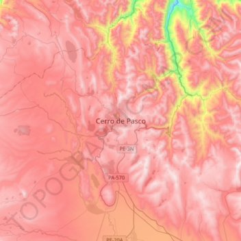
Nome: Mapa topográfico Cerro de Pasco, altitude, relevo.
Altitude média: 4239 m
Altitude mínima: 3386 m
Altitude máxima: 4602 m
Cerro de Pasco is a city in central Peru, located at the top of the Andean Mountains. It is the capital of both the Pasco Province and the Department of Pasco, and an important mining center of silver, copper, zinc and lead. At an elevation of 4,330 metres (14,210 ft), it is one of the highest cities in the world, and with a population of 58,899, it is the highest or the second highest city with over 50,000 inhabitants. The elevation reaches up to 4,380 metres or 14,370 feet in the Yanacancha area. The city has a very intense cold climate and it is connected by road and by rail (via Ferrocarril Central Andino) to the capital Lima, 300 kilometres or 190 miles away. Its urban area is formed by the districts of Chaupimarca, Yanacancha and Simón Bolívar.
Outros mapas topográficos
Clique em um mapa para visualizar sua topografia, sua altitude e seu relevo.
Huayllay National Sanctuary
Huayllay National Sanctuary, Huayllay, Province of Pasco, Pasco, Peru
Altitude média: 4284 m
Huarautambo
Huarautambo, Yanahuanca, Province of Daniel Carrión, Pasco, Peru
Altitude média: 3931 m
San Alberto
Peru > Pasco > Oxapampa > La Esperanza
San Alberto, La Esperanza, Oxapampa, Province of Oxapampa, Pasco, Peru
Altitude média: 1926 m
Machicura
Peru > Pasco > Chontabamba > Machicura
Machicura, Chontabamba, Province of Oxapampa, Pasco, Peru
Altitude média: 1878 m