
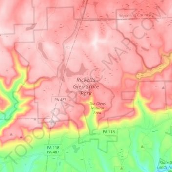
Mapa topográfico Ricketts Glen State Park
Mapa interativo
Clique no mapa para exibir a altitude.
Sobre este mapa
Nome: Mapa topográfico Ricketts Glen State Park, altitude, relevo.
Altitude média: 588 m
Altitude mínima: 282 m
Altitude máxima: 751 m
The state's original plans for the new park included building an inn, an 18-hole golf course and country club, and a winter sports complex for skiing, ice boating, and tobogganing, as well as a beach with bathing facilities, cabins, and a tent camping area. Only the last three were actually built, all south of Lake Jean; the Hayfield area north of Lake Jean was to have had the facilities for golf and tennis, and the inn and winter sports complex were to have been atop Cherry Ridge, at an elevation of 2,461 feet (750 m).
Outros mapas topográficos
Clique em um mapa para visualizar sua topografia, sua altitude e seu relevo.
Lake Leigh Dam (defunct)
United States > Pennsylvania > Luzerne County > Fairmount Township
Lake Leigh Dam (defunct), Fairmount Township, Luzerne County, Pennsylvania, United States
Altitude média: 672 m
Red Rock
United States > Pennsylvania > Luzerne County > Fairmount Township
Red Rock, Fairmount Township, Luzerne County, Pennsylvania, United States
Altitude média: 438 m