
Mapa topográfico Ladismith
Mapa interativo
Clique no mapa para exibir a altitude.
Sobre este mapa
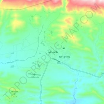
Nome: Mapa topográfico Ladismith, altitude, relevo.
Altitude média: 605 m
Altitude mínima: 426 m
Altitude máxima: 1132 m
It is situated adjacent to a series of fertile, irrigated valleys, at an elevation of 550 m above sea level, at the southern base of the Swartberg. It is currently included in the southern Kannaland Local Municipality. The nearest towns are Calitzdorp to the east, Vanwyksdorp and Riversdale to the south and Laingsburg to the north.