
Mapa topográfico Uelleben
Mapa interativo
Clique no mapa para exibir a altitude.
Sobre este mapa
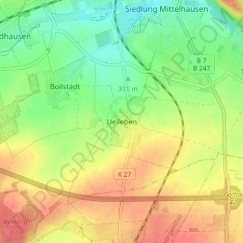
Nome: Mapa topográfico Uelleben, altitude, relevo.
Altitude média: 329 m
Altitude mínima: 299 m
Altitude máxima: 361 m
Outros mapas topográficos
Clique em um mapa para visualizar sua topografia, sua altitude e seu relevo.
Siebleben
Deutschland > Thüringen > Landkreis Gotha > Gotha
Siebleben, Gotha, Landkreis Gotha, Thüringen, 99867, Deutschland
Altitude média: 297 m