
Obrigado por apoiar este site ❤️
Faça uma doação
Faça uma doação
Prepare-se para a sua próxima aventura:
Como Associado da Amazon, este site recebe uma comissão sobre compras elegíveis sem custo adicional para si.
Mapa topográfico Dunvegan
Clique no mapa para exibir a altitude.
Obrigado por apoiar este site ❤️
Faça uma doação
Faça uma doação
Prepare-se para a sua próxima aventura:
Como Associado da Amazon, este site recebe uma comissão sobre compras elegíveis sem custo adicional para si.
Sobre este mapa
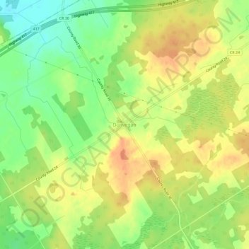
Nome: Mapa topográfico Dunvegan, altitude, relevo.
Altitude média: 87 m
Altitude mínima: 64 m
Altitude máxima: 103 m
Obrigado por apoiar este site ❤️
Faça uma doação
Faça uma doação
Prepare-se para a sua próxima aventura:
Como Associado da Amazon, este site recebe uma comissão sobre compras elegíveis sem custo adicional para si.
Outros mapas topográficos
Clique em um mapa para visualizar sua topografia, sua altitude e seu relevo.
Middle Lake
Canada > Ontario > Stormont, Dundas and Glengarry Counties > North Glengarry > Alexandria
Altitude média: 90 m