
Mapa topográfico Penida Island
Mapa interativo
Clique no mapa para exibir a altitude.
Sobre este mapa
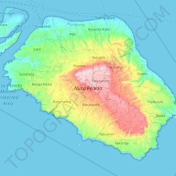
Nome: Mapa topográfico Penida Island, altitude, relevo.
Altitude média: 104 m
Altitude mínima: -4 m
Altitude máxima: 517 m
Nusa Penida (Balinese: ᬦᬸᬲᬧᭂᬦᬶᬤ), romanized: nusapĕnida, lit. 'Penida Island') is an island located near the southeastern Indonesian island of Bali and a district of Klungkung Regency that includes the neighbouring small island of Nusa Lembongan and twelve even smaller islands. The Badung Strait separates the island and Bali. The interior of Nusa Penida is hilly with a maximum altitude of 524 metres. It is drier than the nearby island of Bali. It is one of the major tourist attractions among the three Nusa islands.
Outros mapas topográficos
Clique em um mapa para visualizar sua topografia, sua altitude e seu relevo.
Bireuen
Indonesia > Bali > Klungkung Regency > Batukandik
Bireuen, Batukandik, Nusa Penida Subdistrict, Klungkung Regency, Bali, Lesser Sunda Islands, Indonesia
Altitude média: 82 m