
Faça uma doação
Prepare-se para a sua próxima aventura:
Como Associado da Amazon, este site recebe uma comissão sobre compras elegíveis sem custo adicional para si.
Mapa topográfico Bandar Abbas
Clique no mapa para exibir a altitude.
Faça uma doação
Prepare-se para a sua próxima aventura:
Como Associado da Amazon, este site recebe uma comissão sobre compras elegíveis sem custo adicional para si.
Bandar Abbas
Bandar Abbas is situated on flat ground with an average altitude of 9 metres (30 ft) above sea level. The nearest elevated areas are Mt. Geno, 17 kilometres (11 mi) to the north, and Mt. Pooladi, 16 kilometres (9.9 mi) to the northwest of the city. The closest river to Bandar Abbas is the River Shoor, which rises on Mt. Geno and flows into the Persian Gulf, 10 kilometres (6.2 mi) east of the city. South of the city is the island of Qeshm.
Faça uma doação
Prepare-se para a sua próxima aventura:
Como Associado da Amazon, este site recebe uma comissão sobre compras elegíveis sem custo adicional para si.
Sobre este mapa
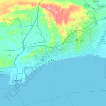
Nome: Mapa topográfico Bandar Abbas, altitude, relevo.
Altitude média: 27 m
Altitude mínima: -5 m
Altitude máxima: 187 m
Faça uma doação
Prepare-se para a sua próxima aventura:
Como Associado da Amazon, este site recebe uma comissão sobre compras elegíveis sem custo adicional para si.
Outros mapas topográficos
Clique em um mapa para visualizar sua topografia, sua altitude e seu relevo.