
Mapa topográfico Silly-en-Gouffern
Mapa interativo
Clique no mapa para exibir a altitude.
Sobre este mapa
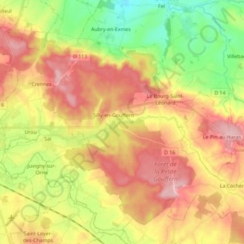
Nome: Mapa topográfico Silly-en-Gouffern, altitude, relevo.
Altitude média: 176 m
Altitude mínima: 95 m
Altitude máxima: 252 m
Outros mapas topográficos
Clique em um mapa para visualizar sua topografia, sua altitude e seu relevo.
Le Bourg-Saint-Léonard
France > Normandie > Orne > Gouffern en Auge
Le Bourg-Saint-Léonard, Gouffern en Auge, Argentan, Orne, Normandie, France métropolitaine, 61310, France
Altitude média: 168 m
Exmes
France > Normandie > Orne > Gouffern en Auge
Exmes, Gouffern en Auge, Argentan, Orne, Normandie, France métropolitaine, 61310, France
Altitude média: 196 m
Chambois
France > Normandie > Orne > Gouffern en Auge
Chambois, Gouffern en Auge, Argentan, Orne, Normandie, France métropolitaine, 61160, France
Altitude média: 115 m
Urou-et-Crennes
France > Normandie > Orne > Gouffern en Auge
Urou-et-Crennes, Gouffern en Auge, Argentan, Orne, Normandie, France métropolitaine, 61200, France
Altitude média: 184 m
Aubry-en-Exmes
France > Normandie > Orne > Gouffern en Auge
Aubry-en-Exmes, Gouffern en Auge, Argentan, Orne, Normandie, France métropolitaine, 61160, France
Altitude média: 130 m
Fel
France > Normandie > Orne > Gouffern en Auge
Fel, Gouffern en Auge, Argentan, Orne, Normandie, France métropolitaine, 61160, France
Altitude média: 123 m