
Faça uma doação
Prepare-se para a sua próxima aventura:
Como Associado da Amazon, este site recebe uma comissão sobre compras elegíveis sem custo adicional para si.
Mapa topográfico Sugar Mountain
Clique no mapa para exibir a altitude.
Faça uma doação
Prepare-se para a sua próxima aventura:
Como Associado da Amazon, este site recebe uma comissão sobre compras elegíveis sem custo adicional para si.
Sugar Mountain
Sugar Mountain has a humid continental climate (Dfb) with warm summers and moderately cold winters, though very cold by North Carolina standards. Due to the village's high elevation, one can experiences all four seasons in equal length on the mountain.
Faça uma doação
Prepare-se para a sua próxima aventura:
Como Associado da Amazon, este site recebe uma comissão sobre compras elegíveis sem custo adicional para si.
Sobre este mapa
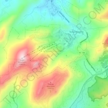
Nome: Mapa topográfico Sugar Mountain, altitude, relevo.
Local: Sugar Mountain, Avery County, North Carolina, United States (36.11463 -81.88628 36.13769 -81.83397)
Altitude média: 1311 m
Altitude mínima: 1121 m
Altitude máxima: 1584 m
Faça uma doação
Prepare-se para a sua próxima aventura:
Como Associado da Amazon, este site recebe uma comissão sobre compras elegíveis sem custo adicional para si.
Outros mapas topográficos
Clique em um mapa para visualizar sua topografia, sua altitude e seu relevo.
Faça uma doação
Prepare-se para a sua próxima aventura:
Como Associado da Amazon, este site recebe uma comissão sobre compras elegíveis sem custo adicional para si.
Faça uma doação
Prepare-se para a sua próxima aventura:
Como Associado da Amazon, este site recebe uma comissão sobre compras elegíveis sem custo adicional para si.
Beech Mountain
United States > North Carolina > Avery County > Beech Mountain
Beech Mountain is a mountain in the North Carolina High Country and wholly in the Pisgah National Forest. Its elevation reaches 5,506 feet (1,657 m) and generates feeder streams for the Elk River. Nestled on the top is the Town of Beech Mountain.
Altitude média: 1433 m
Sugar Mountain
United States > North Carolina > Avery County > Sugar Mountain
Sugar Mountain is a mountain in the North Carolina High Country and wholly in the Pisgah National Forest. Its elevation reaches 5,236 feet (1,596 m) and is split along the Eastern Continental Divide, generating feeder streams for the Linville, Elk, and North Toe rivers. On its north slope resides the Village…
Altitude média: 1385 m
Faça uma doação
Prepare-se para a sua próxima aventura:
Como Associado da Amazon, este site recebe uma comissão sobre compras elegíveis sem custo adicional para si.