
Mapa topográfico Mansuna
Mapa interativo
Clique no mapa para exibir a altitude.
Sobre este mapa
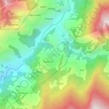
Nome: Mapa topográfico Mansuna, altitude, relevo.
Altitude média: 1653 m
Altitude mínima: 1107 m
Altitude máxima: 2494 m
Outros mapas topográficos
Clique em um mapa para visualizar sua topografia, sua altitude e seu relevo.
Lake Vasuki Tal
India > Uttarakhand > Ukhimath > Kedarnath
Lake Vasuki Tal, Kedarnath, Ukhimath, Rudraprayag District, Uttarakhand, India
Altitude média: 4303 m
Chorabari Glacier
India > Uttarakhand > Ukhimath > Kedarnath
Chorabari Glacier, Kedarnath, Ukhimath, Rudraprayag District, Uttarakhand, India
Altitude média: 5011 m
Uthind
India > Uttarakhand > Ukhimath
Uthind, Ukhimath, Rudraprayag District, Uttarakhand, 246419, India
Altitude média: 1601 m
Khunnu
India > Uttarakhand > Ukhimath
Khunnu, Ukhimath, Rudraprayag District, Uttarakhand, India
Altitude média: 1841 m
Gaurikund
India > Uttarakhand > Ukhimath
Gaurikund, Ukhimath, Rudraprayag, Uttarakhand, India
Altitude média: 2589 m
Kedarnath
India > Uttarakhand > Ukhimath
Kedarnath, Ukhimath, Rudraprayag District, Uttarakhand, India
Altitude média: 4219 m
Sersi
India > Uttarakhand > Ukhimath > Sersi
Sersi, Ukhimath, Rudraprayag, Uttarakhand, 246471, India
Altitude média: 1942 m
Chopta Chatti
India > Uttarakhand > Ukhimath > Chopta Chatti
Chopta Chatti, Ukhimath, Rudraprayag, Uttarakhand, India
Altitude média: 2759 m
Sonprayag
India > Uttarakhand > Ukhimath
Sonprayag, Ukhimath, Rudraprayag, Uttarakhand, 246471, India
Altitude média: 2053 m
Guptkashi
India > Uttarakhand > Ukhimath
Guptkashi, Ukhimath, Rudraprayag District, Uttarakhand, 246439, India
Altitude média: 1449 m