
Mapa topográfico Dover
Mapa interativo
Clique no mapa para exibir a altitude.
Sobre este mapa
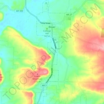
Nome: Mapa topográfico Dover, altitude, relevo.
Local: Dover, Pope County, Arkansas, 72837, United States (35.35115 -93.12742 35.41773 -93.09518)
Altitude média: 164 m
Altitude mínima: 113 m
Altitude máxima: 252 m
The mild hills historically supported oak-hickory forest or oak-hickory-pine forest. Elevation changes and soil types make the Arkansas Valley Hills largely unsuitable for row agriculture. Instead, forest has been cleared for pastureland, poultry farming or ranching. Logging remains an important land use where elevation or soil makes livestock farming unsuitable. Many of the smaller streams and watercourses are completely dry in summer.
Outros mapas topográficos
Clique em um mapa para visualizar sua topografia, sua altitude e seu relevo.
Smyrna
United States > Arkansas > Pope County
Smyrna, Pope County, Arkansas, United States
Altitude média: 402 m
Russellville
United States > Arkansas > Pope County
Russellville, Pope County, Arkansas, United States
Altitude média: 133 m
Dover
United States > Arkansas > Pope County > Dover > Dover
Dover, Pope County, Arkansas, 72837, United States
Altitude média: 150 m
Moreland
United States > Arkansas > Pope County > Moreland
Moreland, Pope County, Arkansas, 72802:72837, United States
Altitude média: 236 m
Worthen
United States > Arkansas > Pope County > Pottsville
Worthen, Pottsville, Pope County, Arkansas, 72858, United States
Altitude média: 143 m