
Mapa topográfico Cesi
Mapa interativo
Clique no mapa para exibir a altitude.
Sobre este mapa
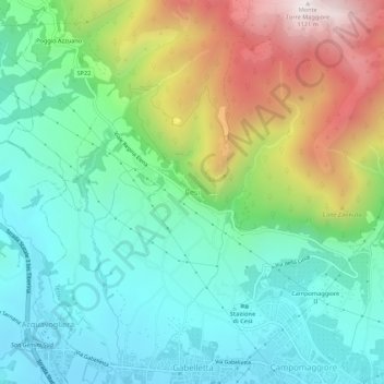
Nome: Mapa topográfico Cesi, altitude, relevo.
Local: Cesi, Terni, Umbria, 05100, Italy (42.58878 12.56650 42.62878 12.60650)
Altitude média: 447 m
Altitude mínima: 139 m
Altitude máxima: 1114 m
Cesi is a frazione of the Italian comune of Terni, in the province of Terni, southern Umbria, Italy. The small borgo, which retains its late-medieval aspect, set among olive groves, lies "stretched out lengthwise along a narrow contour on the slopes of M. Torre Maggiore," about 18 km north of Terni at an altitude of 437 m, one of the southernmost peaks of the Monti Martani. As of 2001 there were 682 residents.
Outros mapas topográficos
Clique em um mapa para visualizar sua topografia, sua altitude e seu relevo.
Monte Torre Maggiore
Italy > Umbria > Terni > Terni
Monte Torre Maggiore, Terni, Umbria, 05100, Italy
Altitude média: 867 m