
Mapa topográfico Xochimilco
Mapa interativo
Clique no mapa para exibir a altitude.
Sobre este mapa
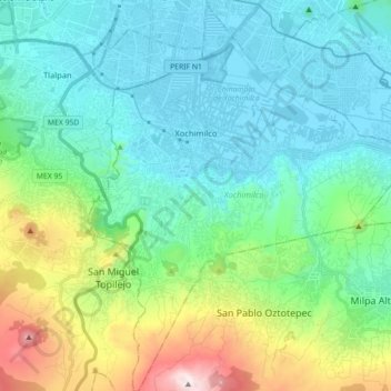
Nome: Mapa topográfico Xochimilco, altitude, relevo.
Local: Xochimilco, Mexico City, Mexico (19.15254 -99.15439 19.32045 -99.00704)
Altitude média: 2513 m
Altitude mínima: 2230 m
Altitude máxima: 3495 m
Much of the borough's land is former lakebed. Its main elevations include Xochitepec and Tlacualleli mountains along with two volcanoes named Teutli and Tzompol. It contains two natural rivers called Santiago and Tepapantla along with the various canals, which is what is left of the lake. The elevated areas of the borough contain small forests of ocotes, strawberry trees, cedars, Montezuma cypress and a tree called a “tepozan.”
Outros mapas topográficos
Clique em um mapa para visualizar sua topografia, sua altitude e seu relevo.
San Miguel Topilejo
San Miguel Topilejo, Mexico City, 14500, Mexico
Altitude média: 2740 m
Alameda Central
Alameda Central, Cuauhtémoc, Mexico City, Mexico
Altitude média: 2235 m
San Miguel Ajusco
San Miguel Ajusco, Mexico City, 14700, Mexico
Altitude média: 2939 m