
Faça uma doação
Prepare-se para a sua próxima aventura:
Como Associado da Amazon, este site recebe uma comissão sobre compras elegíveis sem custo adicional para si.
Mapa topográfico Lighthouse Park
Clique no mapa para exibir a altitude.
Faça uma doação
Prepare-se para a sua próxima aventura:
Como Associado da Amazon, este site recebe uma comissão sobre compras elegíveis sem custo adicional para si.
Lighthouse Park
The sword fern (Polystichum munitum), one of the most abundant ferns in North America, can be found from Alaska to California and is named for its small upward-pointing lobe that resembles a sword hilt. This fern prefers to grow in moist, coniferous low elevation environments but can survive dry periods. Traditionally, this plant has been eaten when no other food source was available, can relieve the pain from the sting of a stinging nettle but now it is mostly used by florists as an ornament.
Faça uma doação
Prepare-se para a sua próxima aventura:
Como Associado da Amazon, este site recebe uma comissão sobre compras elegíveis sem custo adicional para si.
Sobre este mapa
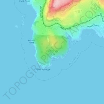
Nome: Mapa topográfico Lighthouse Park, altitude, relevo.
Altitude média: 22 m
Altitude mínima: 0 m
Altitude máxima: 193 m
Faça uma doação
Prepare-se para a sua próxima aventura:
Como Associado da Amazon, este site recebe uma comissão sobre compras elegíveis sem custo adicional para si.
Outros mapas topográficos
Clique em um mapa para visualizar sua topografia, sua altitude e seu relevo.
Yew Lake
Canada > British Columbia > Metro Vancouver Regional District > West Vancouver
Altitude média: 990 m
Black Mountain (North Summit)
Canada > British Columbia > Metro Vancouver Regional District > West Vancouver
Altitude média: 931 m