
Mapa topográfico Stevens Landing
Mapa interativo
Clique no mapa para exibir a altitude.
Sobre este mapa
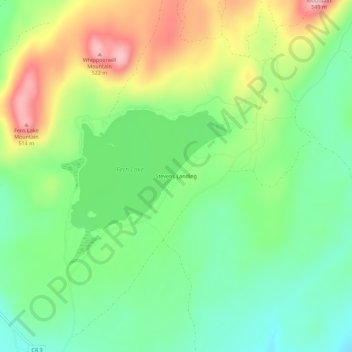
Nome: Mapa topográfico Stevens Landing, altitude, relevo.
Altitude média: 385 m
Altitude mínima: 303 m
Altitude máxima: 518 m
Outros mapas topográficos
Clique em um mapa para visualizar sua topografia, sua altitude e seu relevo.
Au Sable Forks
United States > New York > Clinton County > Town of Black Brook
Au Sable Forks, Town of Black Brook, Clinton County, New York, United States
Altitude média: 238 m