
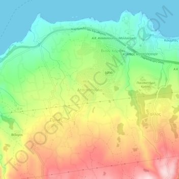
Mapa topográfico Atsipopoulo
Mapa interativo
Clique no mapa para exibir a altitude.
Sobre este mapa
Nome: Mapa topográfico Atsipopoulo, altitude, relevo.
Altitude média: 143 m
Altitude mínima: 0 m
Altitude máxima: 342 m
Outros mapas topográficos
Clique em um mapa para visualizar sua topografia, sua altitude e seu relevo.
Alones
Greece > Region of Crete > Rethymno Regional Unit
Alones, Municipality of Rethymnon, Rethymno Regional Unit, Region of Crete, Greece
Altitude média: 691 m
Preveli Palmbeach
Greece > Region of Crete > Rethymno Regional Unit
Preveli Palmbeach, Municipality of Agios Vasileios, Rethymno Regional Unit, Region of Crete, Greece
Altitude média: 86 m
Rethymno
Greece > Region of Crete > Rethymno Regional Unit > Rethymno
Rethymno, Municipality of Rethymnon, Rethymno Regional Unit, Region of Crete, 741 31, Greece
Altitude média: 204 m
Gerani
Greece > Region of Crete > Rethymno Regional Unit > Gerani
Gerani, Municipality of Rethymnon, Rethymno Regional Unit, Region of Crete, Greece
Altitude média: 126 m
Plakias
Greece > Region of Crete > Rethymno Regional Unit
Plakias, Municipality of Agios Vasileios, Rethymno Regional Unit, Region of Crete, 740 60, Greece
Altitude média: 123 m
Agia Galini
Greece > Region of Crete > Rethymno Regional Unit > Agia Galini
Agia Galini, Municipality of Agios Vasileios, Rethymno Regional Unit, Region of Crete, 74056, Greece
Altitude média: 127 m
Vlichada
Greece > Region of Crete > Rethymno Regional Unit
Vlichada, Municipality of Milopotamos, Rethymno Regional Unit, Region of Crete, Greece
Altitude média: 261 m