
Faça uma doação
Prepare-se para a sua próxima aventura:
Como Associado da Amazon, este site recebe uma comissão sobre compras elegíveis sem custo adicional para si.
Mapa topográfico Taüll
Clique no mapa para exibir a altitude.
Faça uma doação
Prepare-se para a sua próxima aventura:
Como Associado da Amazon, este site recebe uma comissão sobre compras elegíveis sem custo adicional para si.
Taüll
Located at an altitude of 1,520 meters in the Sant Martí valley, a small valley in the Valley of Boí. The closest river is the Sant Martí river, Noguera de Tor affluent. A ravine splits the village in two districts: La Guinsa and Lo Barri. La Guinsa goes from the entrance of the village to the ravine, and Lo Barri goes from the ravine to the high part of the village.
Faça uma doação
Prepare-se para a sua próxima aventura:
Como Associado da Amazon, este site recebe uma comissão sobre compras elegíveis sem custo adicional para si.
Sobre este mapa
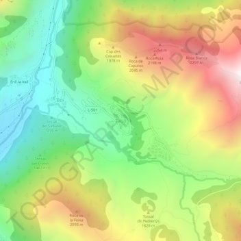
Nome: Mapa topográfico Taüll, altitude, relevo.
Altitude média: 1707 m
Altitude mínima: 1115 m
Altitude máxima: 2498 m
Faça uma doação
Prepare-se para a sua próxima aventura:
Como Associado da Amazon, este site recebe uma comissão sobre compras elegíveis sem custo adicional para si.