
Mapa topográfico Molbergen
Mapa interativo
Clique no mapa para exibir a altitude.
Sobre este mapa
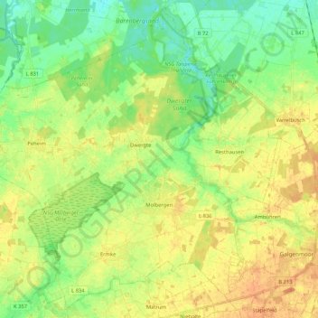
Nome: Mapa topográfico Molbergen, altitude, relevo.
Local: Molbergen, Landkreis Cloppenburg, Nedersaksen, 49696, Duitsland (52.81683 7.79186 52.93660 7.99996)
Altitude média: 34 m
Altitude mínima: 17 m
Altitude máxima: 51 m
Outros mapas topográficos
Clique em um mapa para visualizar sua topografia, sua altitude e seu relevo.
Saterland - Seelterlound
Duitsland > Nedersaksen > Landkreis Cloppenburg
Saterland - Seelterlound, Landkreis Cloppenburg, Nedersaksen, 26683, Duitsland
Altitude média: 5 m
Barßel
Duitsland > Nedersaksen > Landkreis Cloppenburg
Barßel, Landkreis Cloppenburg, Nedersaksen, 26676, Duitsland
Altitude média: 4 m
Addrup
Duitsland > Nedersaksen > Landkreis Cloppenburg > Essen (Oldenburg)
Addrup, Dorfgemeinschaft Addrup, Essen (Oldenburg), Landkreis Cloppenburg, Nedersaksen, Duitsland
Altitude média: 28 m
Neuvrees
Duitsland > Nedersaksen > Landkreis Cloppenburg > Friesoythe
Neuvrees, Friesoythe, Landkreis Cloppenburg, Nedersaksen, 26169, Duitsland
Altitude média: 14 m
Lindern (Oldenburg)
Duitsland > Nedersaksen > Landkreis Cloppenburg > Lindern (Oldenburg)
Lindern (Oldenburg), Landkreis Cloppenburg, Nedersaksen, 49699, Duitsland
Altitude média: 33 m
Cloppenburg
Duitsland > Nedersaksen > Landkreis Cloppenburg
Cloppenburg, Landkreis Cloppenburg, Nedersaksen, 49661, Duitsland
Altitude média: 41 m