
Mapa topográfico Sint-Amandsberg
Mapa interativo
Clique no mapa para exibir a altitude.
Sobre este mapa
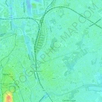
Nome: Mapa topográfico Sint-Amandsberg, altitude, relevo.
Local: Sint-Amandsberg, Gent, Oost-Vlaanderen, Vlaanderen, 9040, België (51.04640 3.74327 51.07740 3.79977)
Altitude média: 8 m
Altitude mínima: -8 m
Altitude máxima: 33 m
Sint-Amandsberg is een sterk verstedelijk dorp dat behoort tot en vastgebouwd is aan de Gentse agglomeratie. De plaats wordt in het zuiden begrensd door de Schelde. De hoogte gaat tot 19 meter, op een stuifzandrug.
Outros mapas topográficos
Clique em um mapa para visualizar sua topografia, sua altitude e seu relevo.
Drongen
België > Oost-Vlaanderen > Gent > Gent
Drongen, Gent, Oost-Vlaanderen, 9031, België
Altitude média: 7 m
Keizerpark
België > Oost-Vlaanderen > Gent > Gent
Keizerpark, Heirnis, Gent, Oost-Vlaanderen, Vlaanderen, 9000, België
Altitude média: 11 m
Sint-Kruis-Winkel
België > Oost-Vlaanderen > Gent > Gent
Sint-Kruis-Winkel, Gent, Oost-Vlaanderen, Vlaanderen, België
Altitude média: 6 m
Gentbrugge
België > Oost-Vlaanderen > Gent > Gent
Gentbrugge, Gent, Oost-Vlaanderen, Vlaanderen, 9050, België
Altitude média: 9 m
Mariakerke
België > Oost-Vlaanderen > Gent > Gent
Mariakerke, Gent, Oost-Vlaanderen, Vlaanderen, 9030, België
Altitude média: 7 m
Oostakker
België > Oost-Vlaanderen > Gent > Gent
Oostakker, Gent, Oost-Vlaanderen, Vlaanderen, 9041, België
Altitude média: 7 m
Zwijnaarde
België > Oost-Vlaanderen > Gent > Gent
Zwijnaarde, Gent, Oost-Vlaanderen, 9052, België
Altitude média: 9 m
Wondelgem
België > Oost-Vlaanderen > Gent > Gent
Wondelgem, Gent, Oost-Vlaanderen, Vlaanderen, België
Altitude média: 6 m
Citadelpark
België > Oost-Vlaanderen > Gent > Gent
Citadelpark, Gent, Oost-Vlaanderen, Vlaanderen, 9000, België
Altitude média: 11 m
Nationale Watersportbaan Georges Nachez
België > Oost-Vlaanderen > Gent > Gent
Nationale Watersportbaan Georges Nachez, Gent, Oost-Vlaanderen, Vlaanderen, België
Altitude média: 7 m
Sint-Denijs-Westrem
België > Oost-Vlaanderen > Gent > Gent
Sint-Denijs-Westrem, Gent, Oost-Vlaanderen, 9051, België
Altitude média: 7 m
Ledeberg
België > Oost-Vlaanderen > Gent > Gent
Ledeberg, Gent, Oost-Vlaanderen, België
Altitude média: 11 m
Desteldonk
België > Oost-Vlaanderen > Gent > Gent
Desteldonk, Gent, Oost-Vlaanderen, 9042, België
Altitude média: 6 m
Mendonk
België > Oost-Vlaanderen > Gent > Gent
Mendonk, Gent, Oost-Vlaanderen, Vlaanderen, België
Altitude média: 5 m
Langerbrugge-eiland
België > Oost-Vlaanderen > Gent > Gent
Langerbrugge-eiland, Gent, Oost-Vlaanderen, 9940, België
Altitude média: 6 m
Afsnee
België > Oost-Vlaanderen > Gent > Gent
Afsnee, Gent, Oost-Vlaanderen, België
Altitude média: 7 m