
Mapa topográfico Redington Shores
Mapa interativo
Clique no mapa para exibir a altitude.
Redington Shores
According to the United States Census Bureau, the town has a total area of 1.2 square miles (3.1 km2), of which 0.4 square miles (1.0 km2) is land and 0.8 square miles (2.1 km2) (67.50%) is water. According to Elevation Map Logs, the elevation of Redington Shores is just one meter above sea level.
Sobre este mapa
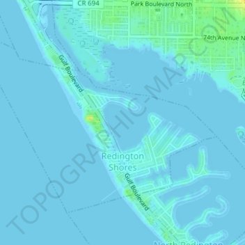
Nome: Mapa topográfico Redington Shores, altitude, relevo.
Local: Redington Shores, Pinellas County, Florida, United States (27.82038 -82.84810 27.84057 -82.81703)
Altitude média: 2 m
Altitude mínima: -2 m
Altitude máxima: 21 m
Outros mapas topográficos
Clique em um mapa para visualizar sua topografia, sua altitude e seu relevo.
Largo
United States > Florida > Pinellas County > Largo
In 2010, Largo's total area was 18.6 square miles (48.1 km2), of which 17.6 square miles (45.6 km2) was land and 0.97 square miles (2.5 km2), or 5.22%, was water. As of 2004, there were 651 acres (2.6 km2) of park lands. The city's lowest elevation is sea level. At its highest, the city's elevation is about 69…
Altitude média: 5 m
West and East Lealman
United States > Florida > Pinellas County > Saint Petersburg
"West and East Lealman" was located at 27°49′12″N 82°41′12″W / 27.82000°N 82.68667°W / 27.82000; -82.68667 (27.820103, -82.686670). The community is adjacent to the cities of Pinellas Park, St. Petersburg, and Kenneth City. The elevation is 49 feet (15 m) above sea level.
Altitude média: 12 m
West and East Lealman
United States > Florida > Pinellas County
"West and East Lealman" was located at 27°49′12″N 82°41′12″W / 27.82000°N 82.68667°W / 27.82000; -82.68667 (27.820103, -82.686670). The community is adjacent to the cities of Pinellas Park, St. Petersburg, and Kenneth City. The elevation is 49 feet (15 m) above sea level.
Altitude média: 10 m
Lealman
United States > Florida > Pinellas County
Lealman is located at 27°49′10″N 82°41′4″W / 27.81944°N 82.68444°W / 27.81944; -82.68444 (27.8197, -82.6846). The community is bordered by the city of Pinellas Park to the north, St. Petersburg to the east and south, and by the town of West Lealman to the west. The elevation is 49 feet (15…
Altitude média: 13 m