
Mapa topográfico Alfeld (Leine)
Mapa interativo
Clique no mapa para exibir a altitude.
Sobre este mapa
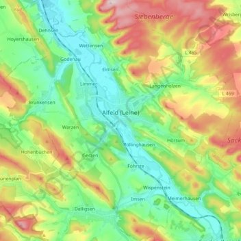
Nome: Mapa topográfico Alfeld (Leine), altitude, relevo.
Altitude média: 191 m
Altitude mínima: 78 m
Altitude máxima: 390 m
Outros mapas topográficos
Clique em um mapa para visualizar sua topografia, sua altitude e seu relevo.
Detfurth
Germany > Lower Saxony > Landkreis Hildesheim > Bad Salzdetfurth
Detfurth, Bad Salzdetfurth, Landkreis Hildesheim, Lower Saxony, 31162, Germany
Altitude média: 158 m
Hildesheim
Germany > Lower Saxony > Landkreis Hildesheim
Hildesheim, Landkreis Hildesheim, Lower Saxony, Germany
Altitude média: 120 m
Nordstemmen
Germany > Lower Saxony > Landkreis Hildesheim
Nordstemmen, Landkreis Hildesheim, Lower Saxony, 31171, Germany
Altitude média: 100 m