
Mapa topográfico Naxos
Mapa interativo
Clique no mapa para exibir a altitude.
Sobre este mapa
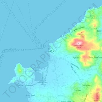
Nome: Mapa topográfico Naxos, altitude, relevo.
Altitude média: 33 m
Altitude mínima: -2 m
Altitude máxima: 326 m
Outros mapas topográficos
Clique em um mapa para visualizar sua topografia, sua altitude e seu relevo.
Naxos
Greece > Aegean > Naxos Regional Unit
Naxos, Naxos Regional Unit, South Aegean, Aegean, Greece
Altitude média: 112 m
Amorgos
Greece > Aegean > Naxos Regional Unit
Amorgos, Naxos Regional Unit, South Aegean, Aegean, 840 08, Greece
Altitude média: 28 m
Keros
Greece > Aegean > Naxos Regional Unit
Keros, Municipality of Naxos and the Lesser Cyclades, Naxos Regional Unit, South Aegean, Aegean, Greece
Altitude média: 42 m