
Mapa topográfico East Amherst
Mapa interativo
Clique no mapa para exibir a altitude.
Sobre este mapa
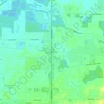
Nome: Mapa topográfico East Amherst, altitude, relevo.
Altitude média: 183 m
Altitude mínima: 176 m
Altitude máxima: 196 m
Outros mapas topográficos
Clique em um mapa para visualizar sua topografia, sua altitude e seu relevo.
Wolcottsburg
United States > New York > Erie County > Town of Clarence
Wolcottsburg, Town of Clarence, Erie County, New York, 14032, United States
Altitude média: 180 m
Harris Hill
United States > New York > Erie County > Town of Clarence
Harris Hill, Town of Clarence, Erie County, New York, United States
Altitude média: 212 m
Clarence Center
United States > New York > Erie County > Town of Clarence
Clarence Center, Town of Clarence, Erie County, New York, United States
Altitude média: 195 m
Spaulding Lake
United States > New York > Erie County > Town of Clarence
Spaulding Lake, Town of Clarence, Newstead, Erie County, New York, United States
Altitude média: 222 m