
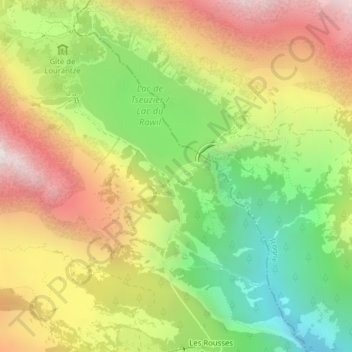
Mapa topográfico Lac de Tseuzier
Mapa interativo
Clique no mapa para exibir a altitude.
Sobre este mapa
Nome: Mapa topográfico Lac de Tseuzier, altitude, relevo.
Local: Lac de Tseuzier, Ayent, Hérens, Wallis, 1966, Switzerland (46.33548 7.42324 46.35548 7.44324)
Altitude média: 1871 m
Altitude mínima: 1224 m
Altitude máxima: 2576 m
Outros mapas topográficos
Clique em um mapa para visualizar sua topografia, sua altitude e seu relevo.
Schnidehorn
Switzerland > Wallis > Hérens > Ayent
Schnidehorn, Ayent, Hérens, Wallis, 1966, Switzerland
Altitude média: 2566 m
Bonnefille
Switzerland > Wallis > Hérens > Ayent > Anzère
Bonnefille, Anzère, Ayent, Hérens, Wallis, 1972, Switzerland
Altitude média: 1408 m
Wildhorn
Switzerland > Wallis > Hérens > Ayent
Wildhorn, Ayent, Hérens, Wallis, 1966, Switzerland
Altitude média: 2768 m
Anzère
Switzerland > Wallis > Hérens > Ayent
Anzère, Ayent, Hérens, Wallis, 1972, Switzerland
Altitude média: 1493 m