
Mapa topográfico Villa Hills
Mapa interativo
Clique no mapa para exibir a altitude.
Sobre este mapa
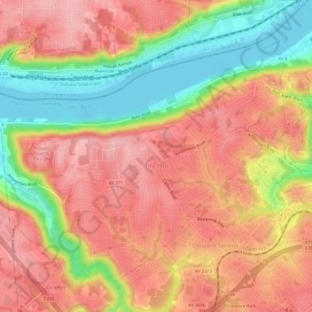
Nome: Mapa topográfico Villa Hills, altitude, relevo.
Local: Villa Hills, Kenton County, Kentucky, United States (39.04590 -84.62370 39.08363 -84.56358)
Altitude média: 224 m
Altitude mínima: 140 m
Altitude máxima: 278 m
Outros mapas topográficos
Clique em um mapa para visualizar sua topografia, sua altitude e seu relevo.
Morning View
United States > Kentucky > Kenton County
Morning View, Kenton County, Kentucky, 41063, United States
Altitude média: 192 m
Taylor Mill
United States > Kentucky > Kenton County
Taylor Mill, Kenton County, Kentucky, 41015, United States
Altitude média: 211 m
Covington
United States > Kentucky > Kenton County > Covington
Covington, Kenton County, Kentucky, United States
Altitude média: 215 m
Sunny Acres
United States > Kentucky > Kenton County > Taylor Mill > Sunny Acres
Sunny Acres, Taylor Mill, Kenton County, Kentucky, 41015, United States
Altitude média: 216 m
Lakeside Park
United States > Kentucky > Kenton County
Lakeside Park, Kenton County, Kentucky, 41017, United States
Altitude média: 255 m