
Mapa topográfico Wetterfeld
Mapa interativo
Clique no mapa para exibir a altitude.
Sobre este mapa
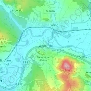
Nome: Mapa topográfico Wetterfeld, altitude, relevo.
Local: Wetterfeld, Roding, Landkreis Cham, Bayern, 93483, Deutschland (49.20095 12.52367 49.24095 12.56367)
Altitude média: 388 m
Altitude mínima: 353 m
Altitude máxima: 515 m
Outros mapas topográficos
Clique em um mapa para visualizar sua topografia, sua altitude e seu relevo.
Oberkreith
Deutschland > Bayern > Landkreis Cham > Roding
Oberkreith, Roding, Landkreis Cham, Bayern, 93426, Deutschland
Altitude média: 386 m
Heidersberg
Deutschland > Bayern > Landkreis Cham > Roding
Heidersberg, Roding, Landkreis Cham, Bayern, 93483, Deutschland
Altitude média: 415 m
Trasching
Deutschland > Bayern > Landkreis Cham > Roding
Trasching, Roding, Landkreis Cham, Bayern, Deutschland
Altitude média: 463 m
Strahlfeld
Deutschland > Bayern > Landkreis Cham > Roding
Strahlfeld, Roding, Landkreis Cham, Bayern, 93426, Deutschland
Altitude média: 413 m