
Mapa topográfico Crans-Montana
Mapa interativo
Clique no mapa para exibir a altitude.
Sobre este mapa
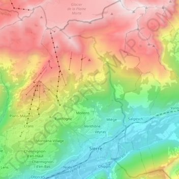
Nome: Mapa topográfico Crans-Montana, altitude, relevo.
Local: Crans-Montana, Sierre, Wallis, 3960, Switzerland (46.27218 7.45877 46.38897 7.58017)
Altitude média: 1660 m
Altitude mínima: 508 m
Altitude máxima: 3155 m
The resort is located in the heart of the Swiss Alps in the French-speaking part of the canton of Valais. It is located on a plateau above Sierre at an elevation of about 1,500 m (4,920 ft) above sea level, allowing good view over the Valais Alps and Weisshorn in particular. The resort is a fusion of the two centers of Crans and Montana and belongs to 6 municipalities (Chermignon, Icogne, Lens, Mollens, Montana and Randogne).
Outros mapas topográficos
Clique em um mapa para visualizar sua topografia, sua altitude e seu relevo.
Lac de Chermignon
Switzerland > Wallis > Sierre > Plans-Mayens
Lac de Chermignon, Plans-Mayens, Lens, Sierre, Wallis, 3960, Switzerland
Altitude média: 1548 m
Lac de Châteaupré
Switzerland > Wallis > Sierre > Anniviers
Lac de Châteaupré, Anniviers, Sierre, Wallis, 3961, Switzerland
Altitude média: 2646 m
Zinal
Switzerland > Wallis > Sierre > Anniviers
Zinal, Anniviers, Sierre, Wallis, 3961, Switzerland
Altitude média: 2209 m
Chandolin
Switzerland > Wallis > Sierre > Anniviers
Chandolin, Anniviers, Sierre, Wallis, 3961, Switzerland
Altitude média: 1901 m
Randogne
Switzerland > Wallis > Sierre > Crans-Montana
Randogne, Crans-Montana, Sierre, Wallis, 3960, Switzerland
Altitude média: 1614 m
Couronne de Bréona
Switzerland > Wallis > Sierre > Anniviers
Couronne de Bréona, Anniviers, Sierre, Wallis, 3961, Switzerland
Altitude média: 2720 m