
Mapa topográfico Jayapura
Mapa interativo
Clique no mapa para exibir a altitude.
Sobre este mapa
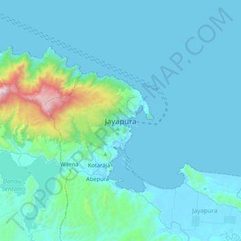
Nome: Mapa topográfico Jayapura, altitude, relevo.
Local: Jayapura, Papua, 99111, Indonesia (-2.69875 140.54374 -2.37875 140.86374)
Altitude média: 149 m
Altitude mínima: 0 m
Altitude máxima: 1660 m
The topography of Jayapura varies from valleys to hills, plateaus, and mountains up to 700 metres (2,300 ft) above sea level. Jayapura overlooks the Yos Sudarso Bay. Jayapura is about 94,000 hectares (230,000 acres) in area, and is divided into five districts. Around 30% of the area is inhabited, with the remainder consisting of a rough terrain, swamps, and protected forest. The average temperature is 29–31.8 °C (84.2–89.2 °F).