
Mapa topográfico Cairo
Mapa interativo
Clique no mapa para exibir a altitude.
Sobre este mapa
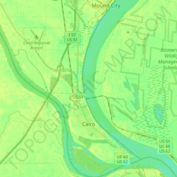
Nome: Mapa topográfico Cairo, altitude, relevo.
Local: Cairo, Alexander County, Illinois, 62914, United States (36.97030 -89.23146 37.08887 -89.13292)
Altitude média: 95 m
Altitude mínima: 85 m
Altitude máxima: 107 m
Cairo (/ˈkɛəroʊ/ KAIR-oh, sometimes /ˈkeɪroʊ/ KAY-roh) is the southernmost city in Illinois and the county seat of Alexander County. A river city, Cairo has the lowest elevation of any location in Illinois and is the only Illinois city to be surrounded by levees. It is in the river-crossed area of Southern Illinois known as "Little Egypt", for which the city is named, after Egypt's capital on the Nile. The city is coterminous with Cairo Precinct.
Outros mapas topográficos
Clique em um mapa para visualizar sua topografia, sua altitude e seu relevo.
Cairo
United States > Illinois > Alexander County > Cairo > Cairo
Cairo, Alexander County, Illinois, 62914, United States
Altitude média: 95 m
Dogtooth Bend Mounds
United States > Illinois > Alexander County
Dogtooth Bend Mounds, Alexander County, Illinois, 62962, United States
Altitude média: 98 m
McClure
United States > Illinois > Alexander County
McClure, Alexander County, Illinois, United States
Altitude média: 103 m
Big Cypress
United States > Illinois > Alexander County
Big Cypress, Alexander County, Illinois, 62969, United States
Altitude média: 101 m
Thebes
United States > Illinois > Alexander County
Thebes, Alexander County, Illinois, 62990, United States
Altitude média: 119 m