
Mapa topográfico Charles Town
Mapa interativo
Clique no mapa para exibir a altitude.
Sobre este mapa
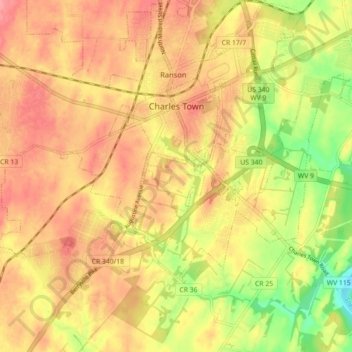
Nome: Mapa topográfico Charles Town, altitude, relevo.
Local: Charles Town, Jefferson County, West Virginia, United States (39.25539 -77.90614 39.29551 -77.81743)
Altitude média: 150 m
Altitude mínima: 99 m
Altitude máxima: 182 m
Due to its low elevation for West Virginia, Charles Town is on the northern extent of the Humid Subtropical climate zone, having cool to mildly cold winters and hot and humid summers. Precipitation is evenly distributed throughout the year, providing lush, abundant plant growth.
Outros mapas topográficos
Clique em um mapa para visualizar sua topografia, sua altitude e seu relevo.
Harpers Ferry
United States > West Virginia > Jefferson County
Harpers Ferry, Jefferson County, West Virginia, United States
Altitude média: 174 m
Shepherdstown
United States > West Virginia > Jefferson County
Shepherdstown, Jefferson County, West Virginia, 25443, United States
Altitude média: 126 m
Kearneysville
United States > West Virginia > Jefferson County > Kearneysville
Kearneysville, Jefferson County, West Virginia, 25430-9047, United States
Altitude média: 162 m
Harpers Ferry National Historical Park
United States > West Virginia > Jefferson County > Bolivar
Harpers Ferry National Historical Park, Bolivar, Jefferson County, West Virginia, United States
Altitude média: 161 m
Halltown
United States > West Virginia > Jefferson County > Halltown
Halltown, Jefferson County, West Virginia, 25423, United States
Altitude média: 133 m