
Mapa topográfico Stone Ridge
Mapa interativo
Clique no mapa para exibir a altitude.
Sobre este mapa
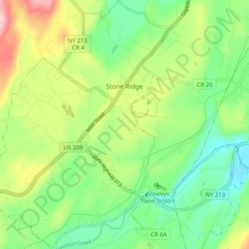
Nome: Mapa topográfico Stone Ridge, altitude, relevo.
Altitude média: 93 m
Altitude mínima: 19 m
Altitude máxima: 222 m
Outros mapas topográficos
Clique em um mapa para visualizar sua topografia, sua altitude e seu relevo.
Mohonk Mountain House Property
United States > New York > Ulster County > Town of Marbletown
Mohonk Mountain House Property, Town of Marbletown, Town of Rochester, Ulster County, New York, United States
Altitude média: 228 m
The Vly
United States > New York > Ulster County > Town of Marbletown
The Vly, Town of Marbletown, Ulster County, New York, 12484, United States
Altitude média: 254 m
High Falls
United States > New York > Ulster County > Town of Marbletown
High Falls, Town of Marbletown, Ulster County, New York, United States
Altitude média: 77 m