Geolocalizar

Mapa topográfico Velloor

Mapa interativo

Clique no mapa para exibir a altitude.

Sobre este mapa

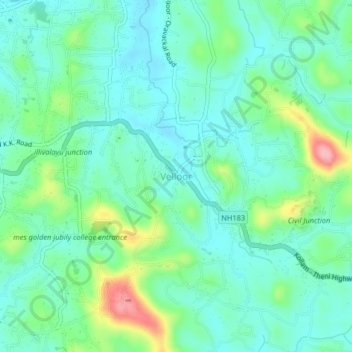
Nome: Mapa topográfico Velloor, altitude, relevo.

Local: Velloor, Kottayam, Kottayam District, Kerala, 686501, India (9.56272 76.58814 9.60272 76.62814)

Altitude média: 38 m

Altitude mínima: 5 m

Altitude máxima: 135 m

Outros mapas topográficos

Clique em um mapa para visualizar sua topografia, sua altitude e seu relevo.

Manganam

India > Kerala > Kottayam

Manganam, Kottayam, Kottayam District, Kerala, 686018, India

Altitude média: 16 m

Pampady

India > Kerala > Kottayam

Pampady, Kottayam, Kottayam District, Kerala, 686502, India

Altitude média: 55 m

Meenadom

India > Kerala > Kottayam > Pariyaram

Meenadom, Pariyaram, Kottayam, Kottayam District, Kerala, 686021, India

Altitude média: 36 m

Sankranthi

India > Kerala > Kottayam > Kottayam

Sankranthi, Kumaranalloor, Kottayam, Kerala, 686028, India

Altitude média: 15 m

Kottayam

India > Kerala > Kottayam

Kottayam, Kottayam District, Kerala, 686001, India

Altitude média: 19 m

Kumarakom

India > Kerala > Kottayam

Kumarakom, Kottayam, Kerala, 686563, India

Altitude média: 2 m

Ettumanoor

India > Kerala > Kottayam

Ettumanoor, Kottayam, Kerala, 686631, India

Altitude média: 22 m

Thiruvanchoor

India > Kerala > Kottayam > Thiruvanchoor

Thiruvanchoor, Kottayam, Kerala, 686032, India

Altitude média: 11 m

Alapuzha

India > Kerala > Kottayam > Kottayam

Alapuzha, Devalokam, Kottayam, Kerala, India

Altitude média: 10 m

Illickal Thazhe

India > Kerala > Kottayam > Kozhikombu > Illickal Thazhe

Illickal Thazhe, Kozhikombu, Kottayam, Kerala, 686635, India

Altitude média: 46 m

Karapuzha

India > Kerala > Kottayam > Kottayam

Karapuzha, Kottayam, Kerala, India

Altitude média: 7 m

Manarcadu

India > Kerala > Kottayam

Manarcadu, Kottayam, Kerala, 686019, India

Altitude média: 23 m