
Mapa topográfico Aizawl
Mapa interativo
Clique no mapa para exibir a altitude.
Sobre este mapa
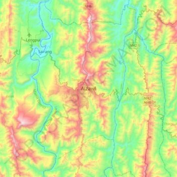
Nome: Mapa topográfico Aizawl, altitude, relevo.
Local: Aizawl, Tlangnuam, Aizwal, Mizoram, 796190, India (23.58352 92.57829 23.90352 92.89829)
Altitude média: 556 m
Altitude mínima: 61 m
Altitude máxima: 1509 m
Aizawl has a mild, sub-tropical climate due to its location and elevation. Under the Köppen climate classification, Aizawl features a humid subtropical climate (Cwa). In summer, temperatures are moderately warm, averaging around 20–30 °C (68–86 °F). In winter, daytime temperatures are cooler in comparison to the rest of the year, averaging around 11–21 °C (52–70 °F). Rainfall is mostly concentrated between April and October, with the heaviest rainfall occurring in May, July, August and September. The remainder of the year is notably drier.
Outros mapas topográficos
Clique em um mapa para visualizar sua topografia, sua altitude e seu relevo.