
Mapa topográfico Usurbil
Mapa interativo
Clique no mapa para exibir a altitude.
Sobre este mapa
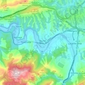
Nome: Mapa topográfico Usurbil, altitude, relevo.
Altitude média: 138 m
Altitude mínima: -4 m
Altitude máxima: 550 m
Outros mapas topográficos
Clique em um mapa para visualizar sua topografia, sua altitude e seu relevo.
Oiartzun
Spain > Autonomous Community of the Basque Country > Donostialdea
Oiartzun, Donostialdea, Gipuzkoa, Autonomous Community of the Basque Country, 20180, Spain
Altitude média: 251 m
Pasaia
Spain > Autonomous Community of the Basque Country > Donostialdea
Pasaia, Donostialdea, Gipuzkoa, Autonomous Community of the Basque Country, 20110, Spain
Altitude média: 40 m
Donostia / San Sebastián
Spain > Autonomous Community of the Basque Country > Donostialdea > Donostia / San Sebastián
Donostia / San Sebastián, San Sebastián, Donostialdea, Gipuzkoa, Autonomous Community of the Basque Country, 20003, Spain
Altitude média: 134 m
Zikuñaga
Spain > Autonomous Community of the Basque Country > Donostialdea > Hernani > Zikuñaga
Zikuñaga, Hernani, Donostialdea, Gipuzkoa, Autonomous Community of the Basque Country, 20120, Spain
Altitude média: 62 m
Errenteria
Spain > Autonomous Community of the Basque Country > Donostialdea
Errenteria, Donostialdea, Gipuzkoa, Autonomous Community of the Basque Country, 20100, Spain
Altitude média: 190 m