
Mapa topográfico Brooklyn Bridge Park
Mapa interativo
Clique no mapa para exibir a altitude.
Sobre este mapa
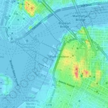
Nome: Mapa topográfico Brooklyn Bridge Park, altitude, relevo.
Altitude média: 9 m
Altitude mínima: -6 m
Altitude máxima: 56 m
Brooklyn Bridge Park spans 85 acres (34 ha) of the East River waterfront in the Brooklyn Heights and Dumbo neighborhoods of Brooklyn. The park is divided into eleven sections: Piers 1 through 6; Fulton Ferry Landing; Brooklyn Bridge Plaza; Empire Fulton Ferry; Main Street; and John Street. Each of these sections features unique topographies, plantings, amenities, and cultural artifacts and installations, and the Brooklyn–Queens Greenway spans the park, as does the Brooklyn Waterfront Greenway.
Outros mapas topográficos
Clique em um mapa para visualizar sua topografia, sua altitude e seu relevo.
Manhattan
United States > New York > New York County > New York
Manhattan, New York County, New York, United States
Altitude média: 16 m
Central Park
United States > New York > New York County > New York
Central Park, New York County, New York, United States
Altitude média: 26 m
Roosevelt Island
United States > New York > New York County > New York
Roosevelt Island, Manhattan, New York County, New York, 10044, United States
Altitude média: 13 m
Battery Park
United States > New York > New York County > New York
Battery Park, Manhattan Community Board 1, Manhattan, New York County, New York, 10004, United States
Altitude média: 3 m
Sara D. Roosevelt Park
United States > New York > New York County > New York
Sara D. Roosevelt Park, Lower East Side, Manhattan, New York County, New York, United States
Altitude média: 14 m
Paley Park
United States > New York > New York County > New York
Paley Park, Midtown East, Manhattan, New York County, New York, 10022, United States
Altitude média: 24 m
Liberty Island
United States > New York > New York County > New York
Liberty Island, Manhattan Community Board 1, Manhattan, New York County, New York, Hudson County, New York, United States
Altitude média: 0 m
Fort Tryon Park
United States > New York > New York County > New York
Fort Tryon Park, Manhattan, New York County, New York, United States
Altitude média: 20 m
Morningside Park
United States > New York > New York County > New York
Morningside Park, Morningside Heights, Manhattan, New York County, New York, United States
Altitude média: 20 m
Bennett Park
United States > New York > New York County > New York
Bennett Park, Hudson Heights, Manhattan, New York County, New York, United States
Altitude média: 24 m
Hunter’s Point South Waterfront Park
United States > New York > New York County > New York
Hunter’s Point South Waterfront Park, Manhattan Community Board 6, Manhattan, New York County, New York, United States
Altitude média: 5 m
Teardrop Park
United States > New York > New York County > New York
Teardrop Park, Manhattan Community Board 1, Manhattan, New York County, New York, United States
Altitude média: 6 m
Governors Island
United States > New York > New York County > New York
Governors Island, Manhattan, New York County, New York, United States
Altitude média: 1 m
Sherman Square
United States > New York > New York County > New York
Sherman Square, Manhattan Community Board 7, Manhattan, New York County, New York, United States
Altitude média: 22 m
Highbridge Park
United States > New York > New York County > New York
Highbridge Park, Manhattan, New York County, New York, United States
Altitude média: 30 m